


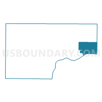
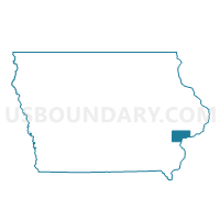
MONTPELIER TWP Voting District, Muscatine County, Iowa
About
Outline

Summary
| Unique Area Identifier | 582918 |
| Name | MONTPELIER TWP Voting District |
| County | Muscatine County |
| State | Iowa |
| Area (square miles) | 22.23 |
| Land Area (square miles) | 21.53 |
| Water Area (square miles) | 0.71 |
| % of Land Area | 96.82 |
| % of Water Area | 3.18 |
| Latitude of the Internal Point | 41.47011580 |
| Longtitude of the Internal Point | -90.83669460 |
Maps

Graphs
Select a template below for downloading or customizing gragh for MONTPELIER TWP Voting District, Muscatine County, Iowa


Neighbors
Neighoring Voting District (by Name) Neighboring Voting District on the Map
- BLUE GRASS IN SCOTT COUNTY Voting District, Scott County, IA
- BUFFALO PRAIRIE Voting District, Rock Island County, IL
- BUFFALO TWP PART W/O BLUE GRASS & BUFFALO Voting District, Scott County, IA
- BUFFALO W/BUFFALO TWP PART Voting District, Scott County, IA
- FULTON TWP W/O BLUEGRASS & WALCOTT Voting District, Muscatine County, IA
- SWEETLAND TWP W/O MUSCATINE Voting District, Muscatine County, IA
Top 10 Neighboring County Subdivision (by Population) Neighboring County Subdivision on the Map
- Buffalo township, Scott County, IA (4,892)
- Blue Grass township, Scott County, IA (4,006)
- Sweetland township, Muscatine County, IA (2,987)
- Montpelier township, Muscatine County, IA (869)
- Buffalo Prairie township, Rock Island County, IL (824)
- Fulton township, Muscatine County, IA (703)
Top 10 Neighboring Place (by Population) Neighboring Place on the Map
Top 10 Neighboring Unified School District (by Population) Neighboring Unified School District on the Map
- Davenport Community School District, IA (106,742)
- Muscatine Community School District, IA (29,454)
- Rockridge Community Unit School District 300, IL (7,392)
Top 10 Neighboring State Legislative District Lower Chamber (by Population) Neighboring State Legislative District Lower Chamber on the Map
- State House District 72, IL (101,862)
- State House District 84, IA (31,647)
- State House District 80, IA (29,774)
Top 10 Neighboring State Legislative District Upper Chamber (by Population) Neighboring State Legislative District Upper Chamber on the Map
- State Senate District 36, IL (206,729)
- State Senate District 42, IA (62,375)
- State Senate District 40, IA (60,420)
Top 10 Neighboring 111th Congressional District (by Population) Neighboring 111th Congressional District on the Map
- Congressional District 17, IL (634,792)
- Congressional District 2, IA (620,856)
- Congressional District 1, IA (596,443)
Top 10 Neighboring Census Tract (by Population) Neighboring Census Tract on the Map
- Census Tract 104.01, Scott County, IA (5,400)
- Census Tract 241.03, Rock Island County, IL (4,046)
- Census Tract 501, Muscatine County, IA (3,465)